(Added authors and description) |
(Added pictures) |
||
| Line 63: | Line 63: | ||
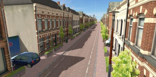
In order to optimize and improve the accessibility of Breda’s city center, the city wanted to evaluate certain redesign options for a specific corridor street, involving citizens throughout the process, communicating in the most visual way possible and creating an experience for all stakeholders. By building the street and the scenario’s in VR, so that all stakeholders and citizens could experience the scenarios in VR while physically cycling on a simulator, we have reduced the projecttime to get to a well accepted decision with 30%. | In order to optimize and improve the accessibility of Breda’s city center, the city wanted to evaluate certain redesign options for a specific corridor street, involving citizens throughout the process, communicating in the most visual way possible and creating an experience for all stakeholders. By building the street and the scenario’s in VR, so that all stakeholders and citizens could experience the scenarios in VR while physically cycling on a simulator, we have reduced the projecttime to get to a well accepted decision with 30%. | ||
<br /> | [[File:Urban future 1.jpeg|500x500px]]<br /> | ||
<br /> | <br /> | ||
Revision as of 13:50, 8 October 2020
Author: |
Wieland hendriksen |
breda, the netherlands, 2017 | |
In order to optimize and improve the accessibility of Breda’s city center, the city wanted to evaluate certain redesign options for a specific corridor street, involving citizens throughout the process, communicating in the most visual way possible and creating an experience for all stakeholders. By building the street and the scenario’s in VR, so that all stakeholders and citizens could experience the scenarios in VR while physically cycling on a simulator, we have reduced the projecttime to get to a well accepted decision with 30%.
Categories:
- Test
- Purpose Activation
- Mechanics Alternative reality
- Mechanics Role play
- Mechanics Rule based play
- Mechanics Location based
- Mechanics Simulations
- Mechanics Mapping
- Mechanics Geolocation
- Mechanics Hypothesis
- Mechanics Metagame
- Technology Tools Analoge Tangibles
- Technology Tools AR VR
- Technology Tools Audio Visual
- Technology Tools Data AI
- Technology Tools Data Collection Visualization
- Technology Tools Digital Interface
- Technology Tools Mobile
- Aesthetics Sensation
- Aesthetics Imagination
- Aesthetics Assemblage
- Aesthetics Physical activity construction
- Aesthetics Realism
- Scale Metropolitan
- Scale City
- Scale District
- Scale Neighbourhood
- Scale Street
- Scale Undefined
- Audience Community
- Audience Planning expert
- Audience Stakeholders
- Audience Policy Makers
- Scope Individual
- Scope Small group
- Scope Large group
- Scope Crowd
- Scope Pre-defined


