(Created blank page) |
|||
| (4 intermediate revisions by the same user not shown) | |||
| Line 1: | Line 1: | ||
[[Category:Project]] | |||
{| | |||
|- | |||
| | |||
<h2>Author:</h2> | |||
| | |||
<h3>Helena H. Rong + Juncheng Yang</h3> | |||
|- | |||
| colspan="2" | | |||
<h4>Cambridge, united states, 2020 | |||
|- | |||
| colspan="2" | | |||
|} | |||
{{GAME | |||
| Purpose_Activation = 1 | |||
| Purpose_Interconnection = 1 | |||
| Purpose_Raise_awareness = 1 | |||
| Purpose_Educate = 1 | |||
| Purpose_Visualise_needs = 0 | |||
| Purpose_Simulate_impact_of_decisions = 0 | |||
| Purpose_Decision_making = 0 | |||
| Purpose_Designing = 0 | |||
| Co-Creation_Co-analysis = 1 | |||
| Co-Creation_Co-design = 0 | |||
| Co-Creation_Co-implementation = 0 | |||
| Co-Creation_Co-maintenance = 0 | |||
| Co-Creation_Co-monitoring = 1 | |||
| Outcome_Decision_making = 0 | |||
| Outcome_Knowledge = 1 | |||
| Outcome_Design = 0 | |||
| Outcome_Inclusion = 1 | |||
| Outcome_Awareness = 1 | |||
| Outcome_Partnership = 1 | |||
|Purpose_Collaborating=1|Outcome_Assessment=0}}{{PLAY | |||
| Aesthetics_Sensation = 0 | |||
| Aesthetics_Imagination = 0 | |||
| Aesthetics_Assemblage = 0 | |||
| Aesthetics_Realism = 1 | |||
| Mechanics_Role_play = 0 | |||
| Mechanics_Rule_based_play = 0 | |||
| Mechanics_Location_based = 1 | |||
| Mechanics_Simulations = 1 | |||
| Mechanics_Mapping = 1 | |||
| Mechanics_Geolocation = 1 | |||
| Mechanics_Hypothesis = 1 | |||
| Mechanics_Metagame = 1 | |||
|Mechanics_Alternative_reality=0|Aesthetics_Physical_activity_construction=0|Technology_Tools_Analoge_Tangibles=1|Technology_Tools_AR_VR=0|Technology_Tools_Audio_Visual=1|Technology_Tools_Data_AI=1|Technology_Tools_Data_Collection_Visualization=1|Technology_Tools_Digital_Interface=1|Technology_Tools_Mobile=0}}{{SPACE | |||
| Scope_Pre-defined = 0 | |||
| Scope_Crowd = 1 | |||
| Scope_Small_group = 0 | |||
| Scope_Individual = 0 | |||
| Audience_Planning_expert = 1 | |||
| Audience_Stakeholders = 1 | |||
| Audience_Community = 1 | |||
| Scale_Street = 0 | |||
| Scale_Neighbourhood = 1 | |||
| Scale_District = 0 | |||
| Scale_Metropolitan = 0 | |||
|Audience_Policy_Makers=1|Scope_Large_group=0|Scale_Undefined=0|Scale_City=0}} | |||
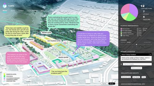
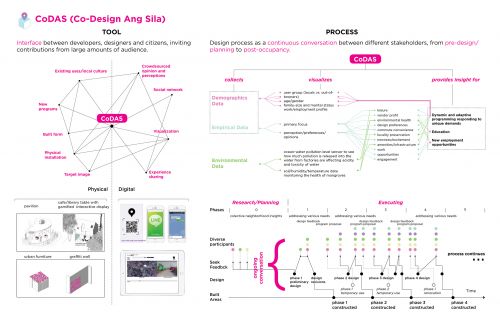
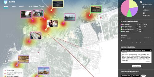
CoDAS is a community-level open platform that combines the scale and instantaneous connectivity of the online network with the kinship created through face-to-face interaction. As a real-time geospatial information platform, CoDAS visualizes proposed changes during development, and engages community residents who are willing to voluntarily contribute to community-building and collective decision making. The tool incentivizes Ang Sila residents to participate actively into the development and design processes of the 35 acre site to ensure their own rights to Ang Sila, instead of accepting passively the outcomes of the processes led by external capitals. In the post-occupancy stage, besides keeping track of current usage of existing shared resources, the platform may connect residents by fostering voluntary groups on various life- or business- related subjects which could help residents generate supplemental income: food tasting, seafood production, marketing, online business, and environmental preservation. With specific interests, these groups along with individuals may compete or collaborate over the use of local resources. These activities are currently organized haphazardly among residents via either word of mouth or across several social media platforms. CoDAS will allow for interconnections and unification of different subject matters within the community by providing a holistic view of the community. In that sense, the platform facilitates a continuous conversation between different stakeholder groups and individuals on various subject matters, hence enabling collective decision-making, collaboration, and supervision. | |||
[[File:CI 1.jpeg|500x500px]]<br />[[File:CI 2.jpeg|500x500px]] | |||
[[File:CI 3.jpeg|500x500px]] | |||
[[File:CI 4.jpeg|500x500px]] | |||
<br /> | |||
Latest revision as of 11:44, 10 November 2020
Author: |
Helena H. Rong + Juncheng Yang |
Cambridge, united states, 2020 | |
CoDAS is a community-level open platform that combines the scale and instantaneous connectivity of the online network with the kinship created through face-to-face interaction. As a real-time geospatial information platform, CoDAS visualizes proposed changes during development, and engages community residents who are willing to voluntarily contribute to community-building and collective decision making. The tool incentivizes Ang Sila residents to participate actively into the development and design processes of the 35 acre site to ensure their own rights to Ang Sila, instead of accepting passively the outcomes of the processes led by external capitals. In the post-occupancy stage, besides keeping track of current usage of existing shared resources, the platform may connect residents by fostering voluntary groups on various life- or business- related subjects which could help residents generate supplemental income: food tasting, seafood production, marketing, online business, and environmental preservation. With specific interests, these groups along with individuals may compete or collaborate over the use of local resources. These activities are currently organized haphazardly among residents via either word of mouth or across several social media platforms. CoDAS will allow for interconnections and unification of different subject matters within the community by providing a holistic view of the community. In that sense, the platform facilitates a continuous conversation between different stakeholder groups and individuals on various subject matters, hence enabling collective decision-making, collaboration, and supervision.
- Project
- Purpose Activation
- Purpose Interconnection
- Purpose Collaborating
- Purpose Raise awareness
- Purpose Educate
- Co-Creation Co-analysis
- Co-Creation Co-monitoring
- Outcome Knowledge
- Outcome Inclusion
- Outcome Awareness
- Outcome Partnership
- Mechanics Location based
- Mechanics Simulations
- Mechanics Mapping
- Mechanics Geolocation
- Mechanics Hypothesis
- Mechanics Metagame
- Technology Tools Analoge Tangibles
- Technology Tools Audio Visual
- Technology Tools Data AI
- Technology Tools Data Collection Visualization
- Technology Tools Digital Interface
- Aesthetics Realism
- Scale Neighbourhood
- Audience Community
- Audience Planning expert
- Audience Stakeholders
- Audience Policy Makers
- Scope Crowd

